- Cucao and Huillinco
-
Cucao and Huillicno Lake
Lago Cucao y Huillinco
View of Cucao Lake Primary outflows Cucao River, also called Desaguadero River Basin countries Chile Surface area 43.8 km² Cucao and Huillinco are two lakes in central Chiloé Island, Chile, linked by a strait forming one hydrologic lake. The two lakes are orinted in west-east fashion cutting of the Chilean Coast Range in Chiloé Island into two ranges; Piuchén to north and Pirulil to the south. The outlet of the lakes, Desaguadero or Cucao River lies at Cucao Lakes western end, and flows into the Pacific.
Hydrography of Los Lagos Region Rivers Waterfalls Petrohué · Salto del IndioLakes Chiloé Archipelago Main islands 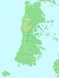
Water bodies Gulf of Ancud · Estero de Castro · Caulín Bay · Chacao Channel · Sea of Chiloé · Gulf of Corcovado · Dalcahue ChannelCities and towns Culture ClothingAsado · Chapalele · Curanto · Licor de oro · Murtado · Mate (Huarisnaque) · Milcao · Murta con membrillo · Paila marina · Potatoes of Chiloé · Pulmay1: These islands are not part of Chiloé ProvinceCategories:- Los Lagos Region geography stubs
- Lakes of Chile
- Geography of Los Lagos Region


Wikimedia Foundation. 2010.