- Roraima
Infobox Brazilian State
name = State of Roraima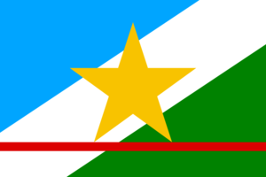
motto =
anthem =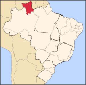
capital = Boa Vista
latd= |latm= |latNS= |longd= |longm= |longEW=
largest_city = Boa Vista
demonym = Roraimense
leader_name1 =
leader_name2 = José de Anchieta Júnior
area = 224,298.98
area_magnitude = 1 E11
area_rank = 14th
population_estimate = 403,344
population_estimate_rank = 24th
population_estimate_year = 2006
population_census = 392,255
population_census_year = 2005
population_density = 1.8
population_density_rank = 27th
GDP = R$ 3,179,000,000
GDP_rank = 27th
GDP_year = 2005
GDP_per_capita = R$ 8,123
GDP_per_capita_rank = 14th
HDI = 0.750
HDI_rank = 17th
HDI_year = 2005
abbreviation = BR-RR
time_zone = BRT
utc_offset = -4
time_zone_DST = BRST
utc_offset_DST = -2Roraima (pronounced|ʁoˈrajma or IPA| [ʁoˈrãjma] [In
Brazilian Portuguese . TheEuropean Portuguese pronunciation is IPA| [hoˈɾajmɐ] .] ) is the northernmost and least populated state ofBrazil , located in the Amazon region.Geography
The climate is tropical with an annual mean temperature of 26°C (78.8°F). Most of the state is located in the
Amazon rainforest , with a small strip ofsavanna to the east. The state is rich in mineral deposits - especiallygold ,diamond s,cassiterite ,bauxite ,marble andcopper . Many of these deposits are located in indigenous reserves, and illegal mining has resulted in frequent conflicts with the native population, especially that of theYanomami and theMacuxi and allied groups.The
Monte Roraima National Park is located around one of the highest mountains of Venezuela, a 2,727 m hightepui known asMonte Roraima .Climate
Except in the higher mountains where the climate is cooler but very wet, Roraima has an
equatorial climate . This is a type oftropical climate in which there is nodry season – all months have meanprecipitation values of at least 60 mm. It is usually found atlatitude s within five degrees of theequator – which are dominated by theIntertropical Convergence Zone . The equatorial climate is denoted "Af" in theKöppen climate classification .Tropical rainforest is the natural vegetation in equatorial regions. clearleftVegetation
The Amazon represents over half of the planet's remaining
rainforest s and comprises the largest and most species-rich tract oftropical rainforest in theworld . Wet tropical forests are the most species-richbiome , and tropical forests in theAmericas are consistently more species rich than the wet forests inAfrica andAsia .Turner, I.M. 2001. "The ecology of trees in the tropical rain forest".Cambridge University Press , Cambridge. ISBN 0-521-80183-4] As the largest tract of tropical rainforest in the Americas, the Amazonian rainforests have unparalleledbiodiversity . More than 1/3 of all species in the world live in the Amazon Rainforest. [ [http://www.worldwildlife.org/wildplaces/amazon/index.cfm Amazon Rainforest, Amazon Plants, Amazon River Animals] ] clearleftHistory
Since the beginnings of the 16th century, the region now considered the state of Roraima was disputed territory, because of its rich
mineral reserves. It was sought by the Spanish, Portuguese, Dutch and English until the beginning of the last century. But in 1943, together with a section from the state ofAmazonas , theFederal Government created the territory ofBranco River , which became Roraima in 1962. In 1988, Roraima became a state by decision of theNational Congress . The name of the state was taken fromMonte Roraima , whose name comes from thePemon words “roroi” (“cyan”) and “ma” (“large”).Demographics
According to the
IBGE of 2007, there were 405,000 people residing in the state. The population density was 1.8 inh./km².Urbanization : 80.3% (2004);Population growth : 4.6% (1991-2000);House s: 97,465 (2005). [Source: PNAD.]The last PNAD (National Research for Sample of Domiciles) census revealed the following numbers: 278,000
Pardo (Brown) people (68.8%), 81,000 White people (20.0%), 29,000 Black people (7.4%), 15,000 Asian or Amerindian people (3.8%). [cite book|url=ftp://ftp.ibge.gov.br/Indicadores_Sociais/Sintese_de_Indicadores_Sociais_2007/Tabelas|title=Síntese de Indicadores Sociais 2007|publisher=IBGE |location=Roraima, Brazil|format=PDF|isbn=85-240-3919-1|accessdate=2007-07-18|year=2007|language=Portuguese]The Brazilian Indian agency, (FUNAI) estimates the state's indigenous population at 30,715. [ [http://www.funai.gov.br FUNAI] ] The largest indigenous groups are the
Macuxi (16,500) [http://www.socioambiental.org/pib/epi/verbetinho/comfoto/macuxi.htm] and the better-knownYanomami . (11,700) [http://www.socioambiental.org/pib/epienglish/yanomami/yanomami.shtm.] Much of the state's indigenous population lives in several large, legally recognized indigenous reserves and a number of smaller ones, totalling 46.13% of the land area of the state. [http://www.socioambiental.org/e/nsa/detalhe?id=2669]Interesting facts
Vehicles : 74,181 (March/2007);Mobile phone s: 148,000 (April/2007);Telephone s: 67,000 (April/2007);Cities : 15 (2007). [Source:IBGE .]Economy
The
service sector is the largest component ofGDP at 87.5%, followed by theindustrial sector at 8.7%.Agriculture represents 3.8%, ofGDP (2004). Roraima exports:wood 74%,leather 22.6% (2002). Share of the Brazilian economy: 0.1% (2005).Education
Portuguese is the official national language, and thus the primary language taught in schools. But English and Spanish are part of the official
high school curriculum.Educational institutions
* Universidade Federal de Roraima (UFRR) (Federal University of Roraima);
* Centro Federal de Educação Tecnológica de Roraima (Cefet-RR);
* Faculdade de Ciências Humanas, Biológicas e da Saúde (FCHBS);
* Faculdade de Teologia de Boa Vista (Fatebov);
* Faculdade Roraimense de Ensino Superior (Fares);
* Faculdades Cathedral - Boa Vista (Cathedral-Boa Vista);
* and many others.Infrastructure
International Airport
Boa Vista International Airport was opened onFebruary 19 ,1973 , and underwent its first big remodeling in 1998. The passenger terminal, runway and apron were all enlarged, and a separatetaxiway was built. Theairport has the capacity to receive 675,000passenger s a year in totalcomfort andsecurity .Highways
*BR-174;
*BR-210;
*BR-431;
*BR-432;
*BR-410;
*RR-171;
*RR-175;
*RR-202;
*RR-203.Flag
The blue of the flag represents the pure air and the sky of Roraima, the white strip symbolizes peace, and the green to the right represents the forests and fields. The star - symbolizing the state in the national flag of Brazil - is yellow, which symbolizes the mineral resources of the state. The red line in bottom stands for the
equator , which cuts through the state. The flag was designed by the artist Mário Barreto, and was adopted by Law No.133 ofJune 14 ,1996 .References
ee also
*en icon
Brazil
*pt icon [http://www.rr.gov.br Official Website]
*en icon [http://www.braziltour.com/site/gb/home/index.php Brazilian Tourism Portal]
*The similarly spelled "Roraimia is also the generic name for theRoraiman Barbtail , a South American bird.


Wikimedia Foundation. 2010.