- Crown Point Light
-
Crown Point Light 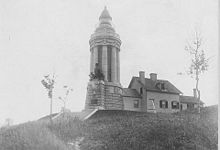
pre-1926 photograph of present Crown Point Light, showing attached keeper's house (USCG) Location on Crown Point on Lake Champlain Coordinates 44°01′48″N 73°25′18″W / 44.0299°N 73.4216°WCoordinates: 44°01′48″N 73°25′18″W / 44.0299°N 73.4216°W Year first lit 1858 Deactivated 1926 Construction stone Tower shape circular colonnade Height 55 ft (17 m) Original lens Fifth-order Fresnel lens The Crown Point Light on Lake Champlain at Crown Point enjoys the unique distinction of having been converted from a conventional lighthouse into a memorial to the exploration of the lake by Samuel de Champlain.
Contents
History
Requests for a light to mark the point date as far back as 1838, but the original light on this site was erected in 1858 by Ellis and O'Neil, along the same lines as the Windmill Point and Isle La Motte lights, which they constructed in the same period. The light sat on a small point due east of Fort Crown Point, an 18th-century British star fort at the tip of the peninsula. The octagonal stone tower and attached keeper's dwelling remained in use, essentially unchanged, into the early 20th century.
The tercentenary of Champlain's explorations of the lake provided the occasion for celebrations marking the event, and commissions from New York and Vermont, put in charge of the festivities, decided to erect a monument. A suggestion in a newspaper prompted the notion to convert an existing lighthouse, and after some consideration of other sites, the Crown Point Light was chosen. The stone sheath of the tower was stripped away, leaving the brick spiral staircase sitting on the foundation. A new tower was constructed on and around this, consisting of a short tapered base, a ring of eight Doric columns, an elaborately carved cornice and parapet, and a new lantern atop the whole. On the side facing the lake, a projection from the base supported a monumental bronze of Champlain and two Indians, sculpted by Carl Augustus Heber; the French government sent a plaque by Auguste Rodin which was later placed below the other sculpture. A broad staircase led down to a pier projecting into the lake. A fifth order Fresnel lens continued to shine in the lantern giving a fixed white light, and the old keeper's house remained in place, attached to the new tower by a short passageway. The memorial was dedicated in 1912 at a ceremony presided over by President Taft.
The memorial served as an active lighthouse for only fourteen years. In 1926 its light was extinguished, and a small skeleton tower was erected immediately adjacent to the water. In 1931 construction of the Crown Point Bridge obscured the site, and the steel tower was moved to the grounds of the Windmill Point Light as part of the customs service effort to control liquor smuggling on the lake. The property was transferred to the State of New York, which continues to maintain it as part of the state park which forms the tip of the peninsula; the keeper's house was demolished, leaving the monument standing alone at the top of the bluff. The tower is marked on navigational charts, but no longer serves as an aid to navigation.
Gallery
-

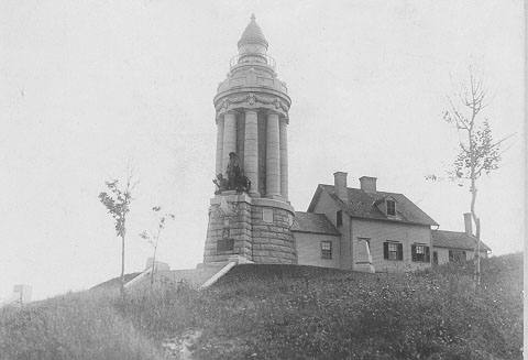
The original Crown Point Light in 1911
-

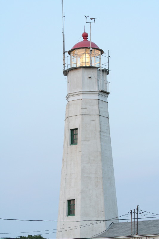
Champlain Memorial Lighthouse, November 2010
References
- "Crown Point Light". lighthousefriends.com. http://www.lighthousefriends.com/light.asp?ID=672. Retrieved 2008-05-20.
- "Historic Light Station Information and Photography: New York". United States Coast Guard Historian's Office. http://www.uscg.mil/history/weblighthouses/LHNY.asp. Retrieved 2008-05-20.
- "Crown Point Lighthouse". Cyber Lighthouses. http://www.cyberlights.com/lh/ny/crownpoint.htm. Retrieved 2008-05-20.
- Holland, Frances Ross (1981). America's Lighthouses: An Illustrated History. Brattleboro, VT: S. Greene Press. pp. 181. http://books.google.com/books?id=f3Ej7zqQTM4C&pg=PA181&lpg=PA181&dq=%22crown+point%22+light&source=web&ots=voaUNsCnz9&sig=6evjZ4LFqdVI9M7sx4v_kFDduaU&hl=en. Retrieved 2008-05-20.
Further reading
- Oleszewski, Wes. Great Lakes Lighthouses, American and Canadian: A Comprehensive Directory/Guide to Great Lakes Lighthouses, (Gwinn, Michigan: Avery Color Studios, Inc., 1998) ISBN 0-932212-98-0.
- Scott T. Price. "U. S. Coast Guard Aids to Navigation: A Historical Bibliography". United States Coast Guard Historian's Office. http://www.uscg.mil/History/weblighthouses/h_lhbib.asp.
- U.S. Coast Guard. Historically Famous Lighthouses (Washington, D.C.: Government Printing Office, 1957).
- Wright, Larry and Wright, Patricia. Great Lakes Lighthouses Encyclopedia Hardback (Erin: Boston Mills Press, 2006) ISBN 1550463993
Lighthouses of New York Ambrose Tower Light · Aunt Phebe Rock Light · Barber's Point Light · Barcelona (Portland Harbor) Light · Blackwell Island Light · Bluff Point Light · Braddock Point Light · Buffalo Light · Buffalo Harbor North and South entrance Lights · Buffalo Harbor South Entrance Light · Buffalo North breakwater East end Light · Buffalo North Breakwater South End Light · Cape Vincent Light · Carleton Island Light · Cedar Island Light · Cold Spring Harbor Light · Coney Island Light · Coxsackie Light · Crossover Island Light · Crown Point Light · Cumberland Head Light · Dunkirk Light · East Charity Shoal Light · Eatons Neck · Elm Tree Beacon Light · Esopus Meadows Light · Execution Rocks Light · Fair Haven Light · Fire Island Light · Fort Niagara Light · Fort Lafayette Light · Fort Tompkins Light · Fort Wadsworth Light · Galloo Island Light · Gardiners Point Island · Horse Island Light · Horton Point Light · Hudson-Athens Light · Huntington Harbor (Lloyd Harbor) Light · Kings Point Light · Latimer Reef Light · Little Gull Island Light · Little Red Lighthouse (Jeffrey's Hook) · Montauk Point Light · Moriches Light · New Dorp Light · North Brother Island Light · North Dumpling Light · Oak Orchard Light · Old Field Point Light · Old Orchard Shoal Light · Ogdensburg Harbor Light · Orient Long Beach Bar Light · Orient Point Light · Oswego Harbor West Pierhead Light · Plattsburgh Beacon Light · Plum Island Light · Point Aux Roches Light · Princes Bay Light · Race Rock Light · Rock Island Light · Romer Shoal Light · Rondout Light · Sands Point Light · Saugerties Light · Selkirk Light · Shinnecock Light · Sodus Outer Light · Sodus Point Light · South Brother Island Channel Range Light · South Buffalo North Side Light · Split Rock Point Light · Staten Island Light · Statue of Liberty · Stepping Stones Light · Stony Point (Henderson) Light · Stony Point Light · Strawberry Island Upper Cut Range Light · Stuyvesant Light · Sunken Meadows Light · Sunken Rock Light · Tarrytown (Sleepy Hollow) Light · Thirty Mile Point Light · (Three) Sisters Island Light · Throgs Neck Light · Tibbetts Point Light · Turkey Point (NY) Light · Watervliet Light · West Point Light · West Bank Light · Whitehall Narrows Light · Whitestone Point Light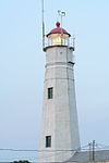 Categories:
- Buildings and structures completed in 1858
- Lighthouses in New York
- Monuments and memorials in New York
-


Wikimedia Foundation. 2010.