- Muharraq
-
This article is about city of Muharraq. For the island, see Muharraq Island. For the administritive division, see Muharraq Governorate.
Al Muharraq View of Muharraq with the skyline of Manama in the background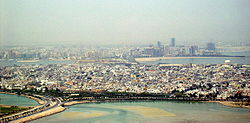 Location in Bahrain
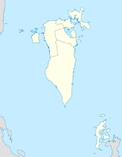
 Al Muharraq
Coordinates: 26°15′N 50°37′E / 26.25°N 50.617°E Country Bahrain Governorate Al Muharraq Governorate Population (2010) – Total 109 695 [1] Muharraq (Arabic: المحرق) (meaning Place of Ashes), is Bahrain's third largest city, and served as its capital until 1923. The Muharraq Town was established by the Sunni Arab tribes in the early nineteenth century.[citation needed] The city is located on Muharraq Island and has long been a centre of religiosity. Bahrain International Airport is located on the island.
The city's origins are ancient, going back to the time of Dilmun some 5,000 years ago, but it came to prominence in the historical records during the era of Tylos when Bahrain came under domination of the Selucid Greeks, and Muharraq was the centre of a pagan cult dedicated to the shark god, Awal. The city's inhabitants, who depended upon seafaring and trade for their livelihood, worshipped Awal in the form of a large statue of a shark located in the city.
By the fifth century AD, Muharraq had become a major centre of Nestorian Christianity, which had come to dominate the southern shores of the Persian Gulf. As a sect, the Nestorians were often persecuted as heretics by the Byzantine Empire, but Bahrain was outside the Empire's control offering safety. The names of several of Muharraq's villages today reflect this Christian legacy, with Al-Dair meaning 'the monastery' and Qalali meaning a 'monk's cloisters'.
Muharraq is home to Muharraq Club, which is Bahrain's most successful football club. The city is also known for its traditional market, or souq, and as a home of traditional arts and music; Ali Bahar, a popular and successful Bahraini singer is from Muharraq. Adjacent to Muharraq are the man-made Amwaj Islands, known for their large buildings, hotels and beaches.
Coordinates: 26°15′N 50°37′E / 26.25°N 50.617°E
Contents
Economy
Gulf Air has its headquarters in Muharraq,[1] and Bahrain Air has its headquarters in the Mohamed Centre in Muharraq.[2][3]
Education
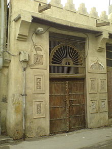 A doorway in the traditional architectural style in Muharraq
The Ministry of Education operates government schools. Boys schools include Abu Farias Al-Hamdani Primary Boys School, Al-Maari Primary Boys School, Hassan bin Thabit Primary Boys School, Omer bin Abdulazeez Primary Boys School, Sheikh Mohammed bin Essa al-Khalifa Primary Boys School, Omer bin Al-Kattab Primary Intermediate Boys School, Abdul-Rahman Al-Nasser Intermediate Boys School, Tariq bin Zeyad Intermediate Boys School, and Moharraq Secondary Boys School. Girls schools include A'amena bint Wahab Primary Girls School, Al-Muharraq Primary Girls School, Mariam bent Omran Primary Girls School, Zubaida Primary Girls School, Istiklal, Khadija al-Kubra Intermediate Girls School, Zanoobia Intermediate Girls School, and Muharraq Secondary Girls School.[4]
See also
- Amwaj Islands, man-made islands near Al Muharraq.
- Christians in the Persian Gulf
References
- ^ Summers, Mark. "'It's business as usual' at Gulf Air." Gulf Daily News. Wednesday 25 July 2007. Retrieved on 24 September 2009.
- ^ "Contact Us." Bahrain Air. Retrieved on 22 June 2010.
- ^ "HQ Map." (image) Bahrain Air. Retrieved on 22 June 2010.
- ^ "Directory." Ministry of Education. Retrieved on 8 September 2009.
Governorates of Bahrain Current divisions 
Former divisions Al Hidd · Manama · Western Region · Central Region · Northern Region · Muharraq · Rifa and Southern Region · Jidd Haffs · Hamad Town · Isa Town · Hawar Islands · SitraISO 3166-2:BHMajor cities of Bahrain Portuguese Empire North Africa15th century
1415–1640 Ceuta
1458–1550 Alcácer Ceguer (El Qsar es Seghir)
1471–1550 Arzila (Asilah)
1471–1662 Tangier
1485–1550 Mazagan (El Jadida)
1487– middle 16th century Ouadane
1488–1541 Safim (Safi)
1489 Graciosa16th century
1505–1769 Santa Cruz do Cabo
de Gué (Agadir)
1506–1525 Mogador (Essaouira)
1506–1525 Aguz (Souira Guedima)
1506–1769 Mazagan (El Jadida)
1513–1541 Azamor (Azemmour)
1515 São João da Mamora (Mehdya)
1577–1589 Arzila (Asilah)Sub-Saharan Africa15th century
1455–1633 Arguin
1470–1975 Portuguese São Tomé1
1474–1778 Annobón
1478–1778 Fernando Poo (Bioko)
1482–1637 Elmina (São Jorge
da Mina)
1482–1642 Portuguese Gold Coast
1496–1550 Madagascar (part)
1498–1540 Mascarene Islands16th century
1500–1630 Malindi
1500–1975 Portuguese Príncipe1
1501–1975 Portuguese E. Africa
(Mozambique)
1502–1659 St. Helena
1503–1698 Zanzibar
1505–1512 Quíloa (Kilwa)
1506–1511 Socotra
1557–1578 Portuguese Accra
1575–1975 Portuguese W. Africa
(Angola)
1588–1974 Cacheu2
1593–1698 Mombassa (Mombasa)17th century
1642–1975 Portuguese Cape Verde
1645–1888 Ziguinchor
1680–1961 São João Baptista de Ajudá
1687–1974 Portuguese Bissau2
18th century
1728–1729 Mombassa (Mombasa)
1753–1975 Portuguese São Tomé and Príncipe
19th century
1879–1974 Portuguese Guinea
1885–1975 Portuguese Congo1 Part of São Tomé and Príncipe from 1753. 2 Part of Portuguese Guinea from 1879. Southwest Asia16th century
1506–1615 Gamru (Bandar-Abbas)
1507–1643 Sohar
1515–1622 Hormuz (Ormus)
1515–1648 Quriyat
1515–? Qalhat
1515–1650 Muscat
1515?–? Barka
1515–1633? Julfar (Ras al-Khaimah)
1521–1602 Bahrain (Muharraq and Manama)
1521–1529? Qatif
1521?–1551? Tarut Island
1550–1551 Qatif
1588–1648 Matrah17th century
1620–? Khor Fakkan
1621?–? As Sib
1621–1622 Qeshm
1623–? Khasab
1623–? Libedia
1624–? Kalba
1624–? Madha
1624–1648 Dibba Al-Hisn
1624?–? Bandar-e KongIndian subcontinent15th century
1498–1545 Laccadive Islands
(Lakshadweep)16th century
Portuguese India
· 1500–1663 Cochim (Kochi)
· 1502–1661 Quilon (Coulão/Kollam)
· 1502–1663 Cannanore (Kannur)
· 1507–1657 Negapatam (Nagapatnam)
· 1510–1962 Goa
· 1512–1525 Calicut (Kozhikode)
· 1518–1619 Chaul
· 1523–1662 Mylapore
· 1528–1666 Chittagong
· 1531–1571 Chalium
· 1534–1601 Salsette Island
· 1534–1661 Bombay (Mumbai)
· 1535–1739 Baçaím (Vasai-Virar)
· 1536–1662 Cranganore (Kodungallur)
· 1540–1612 Surat
· 1548–1658 Tuticorin (Thoothukudi)16th century (continued)
Portuguese India (continued)
· 1559–1962 Daman and Diu
· 1568–1659 Mangalore
· 1579–1632 Hugli
· 1598–1610 Masulipatnam (Machilipatnam)
1518–1521 Maldives
1518–1658 Portuguese Ceylon (Sri Lanka)
1558–1573 Maldives
17th century
Portuguese India
· 1687–1749 Mylapore
18th century
Portuguese India
· 1779–1954 Dadra and Nagar HaveliEast Asia and Oceania16th century
1511–1641 Portuguese Malacca
1512–1621 Ternate
· 1576–1605 Ambon
· 1578–1650 Tidore
1512–1665 Makassar
1553–1999 Portuguese Macau
1571–1639 Decima (Dejima, Nagasaki)17th century
1642–1975 Portuguese Timor (East Timor)1
19th century
Portuguese Macau
· 1864–1999 Coloane
· 1849–1999 Portas do Cerco
· 1851–1999 Taipa
· 1890–1999 Ilha Verde
20th century
Portuguese Macau
· 1938–1941 Lapa and Montanha (Hengqin)1 1975 is the year of East Timor's Declaration of Independence and subsequent invasion by Indonesia. In 2002, East Timor's independence was recognized by Portugal & the world.
North America and the North Atlantic Ocean16th century
1500–1579? Terra Nova (Newfoundland)
1500–1579? Labrador
1516–1579? Nova ScotiaCentral and South America16th century
1500–1822 Brazil
1536–1620 Portuguese Barbados17th century
1680–1777 Nova Colônia do Sacramento
19th century
1808–1822 Cisplatina (Uruguay)Categories:- Populated places in Bahrain
- History of Bahrain
- Former municipalities (regions) of Bahrain
- Bahrain geography stubs


Wikimedia Foundation. 2010.