Bridgegate, Chester

Bridgegate, Chester

Infobox_Bridge
bridge_name=Bridgegate
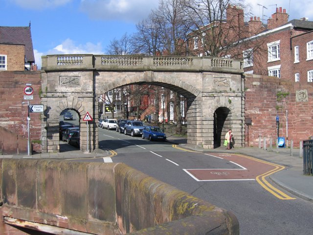


caption=Bridgegate
official_name=
carries=City wall
crosses=Lower Bridge Street
locale=Chester, Cheshire
maint=
id=
designer= Joseph Turner
design= Arch bridge
material= Sandstone
mainspan=
length=
width=
height=
load=
clearance=
below=
traffic=
open=1782
closed=
toll=None
troll=
map_cue=
map_

map_text=
map_width=
coordinates= coord|53.186223|-2.889329|type:landmark_scale:2000_region:GB
lat=53.186223
long=-2.889329

The Bridgegate is in Chester, Cheshire, England between Lower Bridge Street and the Old Dee Bridge (gbmapping|SJ406658). It forms part of the city walls and is a Grade I listed building.cite web |url=http://www.imagesofengland.org.uk/search/details.aspx?pid=1&id=470315 |title=Images of England: The Bridgegate, Chester|accessdate=2008-03-27 |publisher=English Heritage ]

It was built in 1781–82 for Chester City Corporation, replacing a city gatehouse. The architect was Joseph Turner. It is built in yellow sandstone ashlar in neoclassical style and consists of a segmental arch over the carriageway with a round pedestrian archway in each abutment. Along its top are balustraded parapets on each side of the footpath.

ee also

*Northgate, Chester
*Watergate, Chester

References


Wikimedia Foundation. 2010.

Игры ⚽ Поможем решить контрольную работу

Look at other dictionaries:

  • Chester city walls — Part of the southern section of the walls showing the base of a former drum tower and the River Dee . Chester city walls consist of a defensive structure built to protect the city of Chester in Cheshire, England. Their construction was started by …   Wikipedia

  • Chester — For the larger local government district, see Cheshire West and Chester. For other uses, see Chester (disambiguation). Coordinates: 53°11′33″N 2°53′30″W / 53.192 …   Wikipedia

  • Northgate, Chester — Northgate Northgate Carries City wall Crosses Northgate Street Locale Chester …   Wikipedia

  • Watergate, Chester — Infobox Bridge bridge name=Watergate caption=Watergate official name= carries=City wall crosses=A458 locale=Chester, Cheshire maint= id= designer= Joseph Turner design= Arch bridge material= Sandstone mainspan= length= width= height= load=… …   Wikipedia

  • Grade I listed buildings in Chester — Chester is the county town of Cheshire, England. It has a large number of Grade I listed buildings.*Remains of Roman Amphitheatre [cite web |url=http://www.imagesofengland.org.uk/search/details.aspx?pid=1 id=469842 |title=Images of England:… …   Wikipedia

  • Liste der Grade-I-Baudenkmäler in Chester — Chester Cathedral Die Liste der Grade I Baudenkmäler in Chester nennt die als Listed Buildings im Grade I in Chester, dem Hauptort der Grafschaft Cheshire in England. Chester Roman Amphitheatre[1] Chester Cathedral …   Deutsch Wikipedia

  • Grosvenor Park, Chester — Grosvenor Park is a public park in the city of Chester, Cheshire, England (gbmapping|SJ412663). It consists of AcreAndHectare |20| round=2 of land overlooking the River Dee. It is regarded as one of the finest and most complete examples of… …   Wikipedia

  • List of Grade I listed buildings in Cheshire — There are over 6000 Grade I listed buildings in England. This page is a list of these buildings in the county of Cheshire, sub divided by district.Chester* Iron Bridge, Aldford * Beeston Castle: walls of outer bailey * Beeston Castle: walls,… …   Wikipedia

  • Handbridge — infobox UK place country = England latitude= 53.18 longitude= 2.89 official name= Handbridge population= 4,223 os grid reference= SJ415655 shire district= Chester shire county = Cheshire region= North West England post town= CHESTER postcode… …   Wikipedia

  • River Dee (Wales) — For other River Dees in the United Kingdom, see River Dee (disambiguation). Coordinates: 53°21′14″N 3°13′33″W / 53.35389°N 3.22583°W / 53.35389; …   Wikipedia

Share the article and excerpts

Direct link
Do a right-click on the link above
and select “Copy Link”