- Diffa Region
-
Diffa — Region — Location within Niger
Coordinates: 14°N 13°E / 14°N 13°ECoordinates: 14°N 13°E / 14°N 13°E Country  Niger
NigerCapital Diffa Area – Total 156,906 km2 (60,581.7 sq mi) Population (2001 census) – Total 346,595 – Density 2.2/km2 (5.7/sq mi) Time zone West Africa Time (UTC+1) 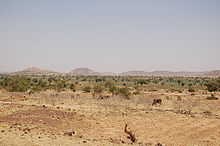 Landscape of rural Diffa Region, Niger, traveling on the main highway from Diffa to Niamey. (2006)
Diffa is an administrative Region of Niger, the capital of the region is the city of Diffa.
Contents
Situation
Diffa Region is situated in the extreme south east of Niger between 10° 30’ and 15° 35’ longitude East and 13° 04’ and 18° 00’ latitude North. It covers 156 906 km², and is bordered to the north by Agadez Region, Zinder Region to the west, and to the south and east by the Federal Republic of Nigeria and the Republic of Chad.
Diffa Region borders:
- Bourkou-Ennedi-Tibesti Department, Chad - northeast
- Kanem Department, Chad - east
- Lac Department, Chad - southeast
- Borno State, Nigeria - south
- Yobe State, Nigeria - southwest
Domestically, it borders the following Regions:
- Zinder Region - west
- Agadez Region - north
Population
The population was estimated in 2000 at 216,245 and 346,595 inhabitants in the 2001 census, consisting of ethnic Kanouris, Hausas, Toubous, Touregs, Fula, and the so-called Diffa Arabs.[1] The total annual growth rate is around 1.2 % and it is one of the least populated areas of Niger ( 2.2 people/km²).
The population is 85% sedentary and 15 % nomadic, practicing seasonal migration with their livestock (Transhumism). The demographic structure, fairly constant over time, is 37% aged less than 20, 57% between 20 - 60, and 6% older than 60 years old.
Administrative subdivisions
 Departments of Diffa
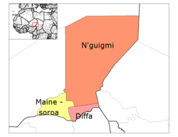
Diffa Region is divided into three Departments:
The Region also includes three Urban Communes, a number of Rural Communes, four Cantons, and over twenty Groupments (administrative councils of nomadic communities).
The Urban Communes are Diffa, Maïné-Soroa, N'guigmi; while the Rural Communes include Bosso, Chétimari, Goudoumaria, N'gourti, Kabléwa, Nguel beyli, and Gueskérou.
Regional economy
The economy of the Diffa Region is primarily agricultural, based upon pastoralism and farming. The major crop, grown both for subsistence and sale, is Millet, especially drought tolerant varieties. One third of arable land is devoted to farming: almost 105,000 hectares farmed of the 299500 hectares of arable land.
Areas of the east and south also grow rice and maize. Irrigation in the valleys around Maïné-Soroa make this possible, as well as does the edge of Lake Chad ( 3,000 km² in the far east) and the seasonal Komadougou Yobe river valley in the south, which forms around 150km of the border with Nigeria.
Despite this the Diffa Region is among the most unproductive agricultural areas in Niger, and all of West Africa, making it especially vulnerable to drought and famine.
See also
- Regions of Niger
- Departments of Niger
- Communes of Niger
- 2010 Sahel famine
References
- ^ Présentation de la région de Diffa: des potentialités naturelles considérables. Abdou Saïdou, Le Sahel (Niamey). 17 December 2009
- Portions of this article were translated from the French language Wikipedia article fr:Diffa (région), 2008-06-19.
- Decalo, Samuel (1997). Historical Dictionary of the Niger (3rd ed.). Boston & Folkestone: Scarecrow Press. ISBN 0810831368.:p. 120
- Geels, Jolijn (2006). Niger. Chalfont St Peter, Bucks / Guilford, CT: Bradt UK / Globe Pequot Press. ISBN 9781841621524.:pp.227-238
- The Wodaabe Of Southeastern Niger. In Nikolaus Schareika. Ecological Knowledge And Herd Movement Strategies Among The Wodaabe Of Southeastern Niger. Institut für Ethnologie und Afrikastudien, Johannes Gutenberg-Universität Mainz/The Food and Agriculture Organization of the United Nations (2003) ISBN 9251050619
Capital: Niamey in Niamey Capital DistrictAgadez Region Diffa Region Dosso Region Maradi Region Aguie Department • Dakoro Department • Guidan Roumdji Department • Madarounfa Department • Mayahi Department • Tessaoua DepartmentTahoua Region Tillabéri Region Zinder Region Categories:- Diffa Region
- Regions of Niger
- Niger geography stubs

Wikimedia Foundation. 2010.